


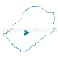
Pleasant Grove First Baptist Church, Jefferson County, Alabama
About
Outline

Summary
| Unique Area Identifier | 522145 |
| Name | Pleasant Grove First Baptist Church |
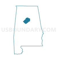
| County | Jefferson County |
| State | Alabama |
| Area (square miles) | 12.54 |
| Land Area (square miles) | 12.54 |
| Water Area (square miles) | 0.00 |
| % of Land Area | 100.00 |
| % of Water Area | 0.00 |
| Latitude of the Internal Point | 33.49948010 |
| Longtitude of the Internal Point | -86.97840280 |
Maps

Graphs
Select a template below for downloading or customizing gragh for Pleasant Grove First Baptist Church, Jefferson County, Alabama


Neighbors
Neighoring Voting District (by Name) Neighboring Voting District on the Map
- Birmingham Fire Station #17, Jefferson County, AL
- Concord Highland Baptist Church, Jefferson County, AL
- Hueytown City Hall, Jefferson County, AL
- Hueytown Council of Clubs, Jefferson County, AL
- Maytown Baptist Church, Jefferson County, AL
- Minor Fire Station, Jefferson County, AL
- Mt. Pilgrim Baptist Church, Jefferson County, AL
- Mulga Town Hall, Jefferson County, AL
- New Bethlehem Baptist Church, Jefferson County, AL
- Sylvan Springs Community Center, Jefferson County, AL
- Sylvan Springs Town Hall, Jefferson County, AL
Top 10 Neighboring County Subdivision (by Population) Neighboring County Subdivision on the Map
- Birmingham CCD, Jefferson County, AL (455,278)
- Concord-Rock Creek CCD, Jefferson County, AL (7,667)
- Maytown-Sylvan Springs CCD, Jefferson County, AL (3,829)
Top 10 Neighboring Place (by Population) Neighboring Place on the Map
- Birmingham city, AL (212,237)
- Hueytown city, AL (16,105)
- Pleasant Grove city, AL (10,110)
- Sylvan Springs town, AL (1,542)
- Edgewater CDP, AL (883)
- McDonald Chapel CDP, AL (717)
- Maytown town, AL (385)
Top 10 Neighboring Unified School District (by Population) Neighboring Unified School District on the Map
Top 10 Neighboring State Legislative District Lower Chamber (by Population) Neighboring State Legislative District Lower Chamber on the Map
- State House District 15, AL (48,965)
- State House District 57, AL (36,199)
- State House District 55, AL (35,572)
Top 10 Neighboring State Legislative District Upper Chamber (by Population) Neighboring State Legislative District Upper Chamber on the Map
Top 10 Neighboring 111th Congressional District (by Population) Neighboring 111th Congressional District on the Map
Top 10 Neighboring Census Tract (by Population) Neighboring Census Tract on the Map
- Census Tract 123.05, Jefferson County, AL (7,947)
- Census Tract 100.01, Jefferson County, AL (5,289)
- Census Tract 125, Jefferson County, AL (4,454)
- Census Tract 140.01, Jefferson County, AL (4,011)
- Census Tract 123.02, Jefferson County, AL (3,829)
- Census Tract 35, Jefferson County, AL (2,795)
- Census Tract 123.04, Jefferson County, AL (2,611)
- Census Tract 139.01, Jefferson County, AL (1,704)
Top 10 Neighboring 5-Digit ZIP Code Tabulation Area (by Population) Neighboring 5-Digit ZIP Code Tabulation Area on the Map
- 35023, AL (25,436)
- 35127, AL (10,099)
- 35005, AL (7,942)
- 35224, AL (6,094)
- 35118, AL (3,138)
- 35061, AL (1,465)